Nathanatos Software
Open-source projects by Nathan Cosgray
Apps
Kingdom of Loathing Data
Methodology
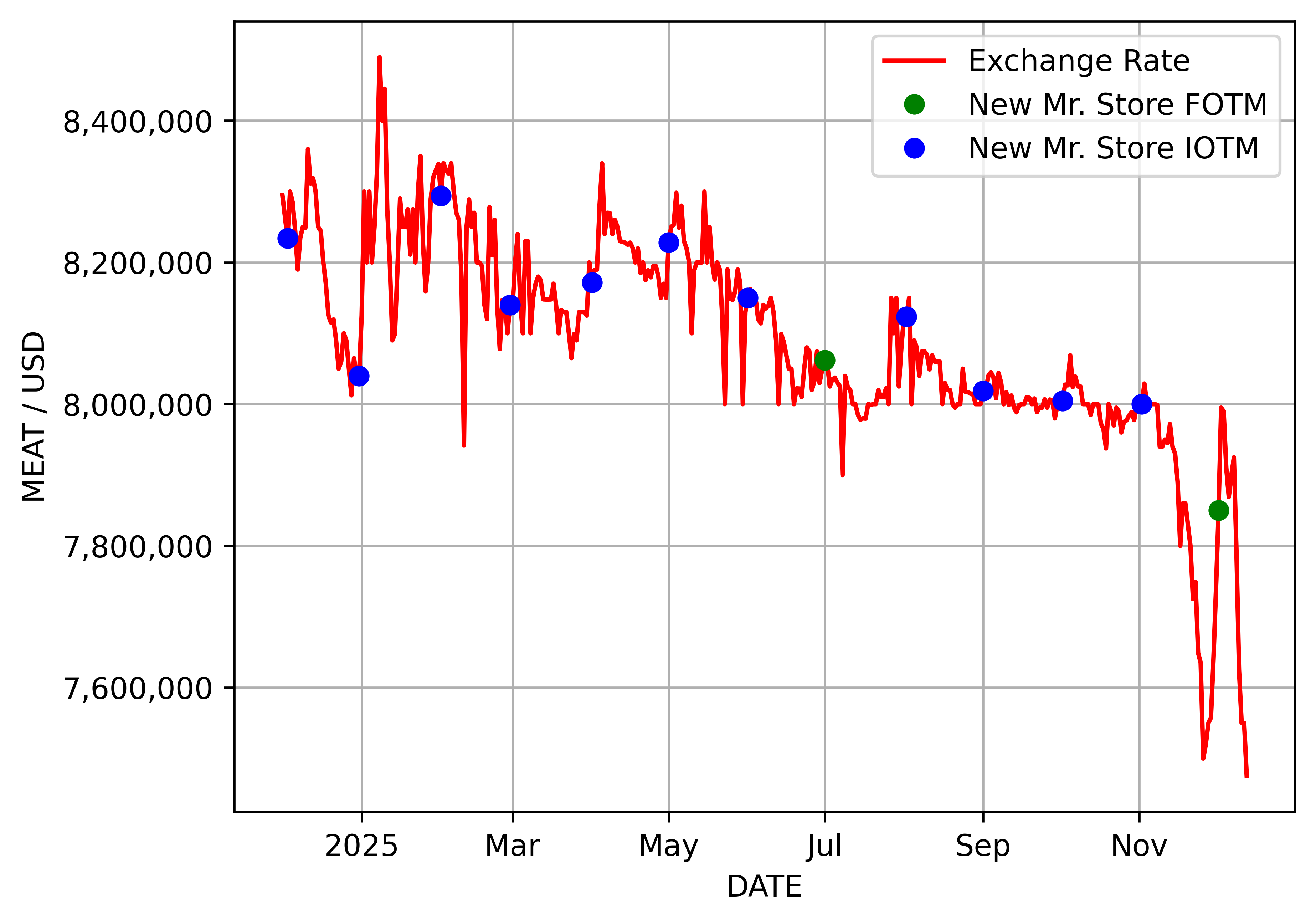
As the only direct financial link between The Kingdom of Loathing and a real-world economy, the Mr. Accessory (an in-game item received in return for donating $10 to the game maintainers) is the perfect indicator by which to measure the current exchange rate. These items are commonly used to amass great in-game wealth; players donate to receive a Mr. A and then sell it in the mall for millions of Meat. The KoL exchange rate can therefore be calculated by finding the current asking price for a Mr. A and dividing this value by 10 to find the $1 conversion factor.
More Data
Raw CSV data files:
Exchange rate history graphs in PNG format:
A detailed reference for monthly Mr. Store offerings can be found on A KoL Wiki.
Neat-o Bonus Thingy
Keep an eye on the exchange rate with a widget on your home screen. Why? Why not! (iOS/macOS widget requires Widgy.)
Tools
I use Kolmafia to output the exchange rate, and D3.js and Matplotlib to create the history graphs. The back-end processing runs on a variety of AWS services. Visit my GitHub repo to learn more.
Privacy Policy
Last Updated: 19 November, 2023
Purpose
I, Nathan Cosgray, built the Cuppa family of apps as simple open-source utilities, and I distribute them via app stores, GitHub, and direct download from my website, www.nathanatos.com. These apps are provided by me at no cost and are provided for use as is. The purpose of this Privacy Policy web page is to inform visitors and app users of my policies related to the collection, use, and disclosure of the personal information of anyone using my apps.
Information Collection and Use
Below is a summary of how information is collected and used by the Cuppa app for each platform.
- Cuppa for Android includes an opt-in option to collect timer usage statistics. Stats collection is disabled by default. If you enable stats collection, Cuppa will record basic information about your timer usage, including the name and settings of each tea, along with the date and time when you start a tea timer. You will then have access to a simple report summarizing your tea drinking habits. Timer usage stats data is only saved locally on your device, but may be also included in device backups (depending on your operating system settings). No personally identifiable data or location information is stored by Cuppa at any time.
- Cuppa for iOS includes an opt-in option to collect timer usage statistics. Stats collection is disabled by default. If you enable stats collection, Cuppa will record basic information about your timer usage, including the name and settings of each tea, along with the date and time when you start a tea timer. You will then have access to a simple report summarizing your tea drinking habits. Timer usage stats data is only saved locally on your device, but may be also included in device backups (depending on your operating system settings). No personally identifiable data or location information is stored by Cuppa at any time.
- Cuppa for macOS does not knowingly collect, store, use, or share the personal information of any user, of any age, for any purpose.
Log Data
Below is a summary of any activity that is logged by the Cuppa app for each platform. Logging includes actions that are recorded by the app or app-related services for tracking user activity, measuring user activity, or any other purpose.
- Cuppa for Android does not generate any log data if timer usage statistics is disabled. If timer usage statistics is enabled, the following data is recorded every time a tea timer is started: tea name, steep time, brewing temperature, tea color, tea icon, starred status, and timer begin date and time. All data is stored in a database local to the device, and no data is transmitted to external systems. If the user subsequently opts out of stats collection, any previously recorded data is purged.
- Cuppa for iOS does not generate any log data if timer usage statistics is disabled. If timer usage statistics is enabled, the following data is recorded every time a tea timer is started: tea name, steep time, brewing temperature, tea color, tea icon, starred status, and timer begin date and time. All data is stored in a database local to the device, and no data is transmitted to external systems. If the user subsequently opts out of stats collection, any previously recorded data is purged.
- The version of Cuppa for macOS distributed via the App Store does not generate any log data.
- The version of Cuppa for macOS distributed via direct download from GitHub or my website uses an updater framework, Sparkle, which, if enabled, accesses an HTTPS-secured URL on my website to periodically check for updates to the app. This feature is called “Check for Updates”. Since the update check occurs over the internet, my web server may store some limited log data related to each periodic check originating from your device. This log data may include information such as your devices’s Internet Protocol (“IP”) address, device name, operating system version, version number of the app installed on your device, the time and date of the update check, and other basic statistics. If you wish to opt out, you will be able to do so the first time you launch the Cuppa macOS app. Opting out will not affect your ability to use or download the Cuppa apps.
Cookies
Cookies are files with small amount of data that are commonly used an anonymous unique identifier. These are sent to your browser from the website that you visit and are stored on your device’s internal memory.
- Cuppa for Android does not use any cookies.
- Cuppa for iOS does not use any cookies.
- Cuppa for macOS does not use any cookies.
- www.nathanatos.com does not use cookies explicitly. However, the website may set some third-party tracking cookies related to my use of Google Analytics for website usage analytics. You have the option to either accept or refuse these cookies by changing your web browser’s privacy settings. If you choose to refuse our cookies, that will not affect your ability to use or download the Cuppa apps.
Children’s Privacy
As stated above, the Cuppa apps do not knowingly collect, store, use, or share the personal information of any user, of any age, for any purpose other than basic timer usage statistics, and no data is transmitted to external systems. If I discover any information about a child under 13 has been inadvertently shared with me, I will immediately purge that information from my systems. Likewise, if you are a parent or guardian and you are aware that your child has provided me with personal information, please contact me, and I will immediately purge that information from my systems.
Changes to This Privacy Policy
I may update this Privacy Policy from time to time. Changes to my Privacy Policy will only be posted here, and this page will be your only notification that an update has occurred. Thus, you are advised to review this page periodically. When posted here, changes to the policy are effective immediately.
Contact Me
If you have any questions about my Privacy Policy, please use the Contact link above to contact me.
Contact Me
Please use the form below to contact me. Fields marked with * are required.